
Rapid Polar Sea Ice Decline Overview
What is sea ice?
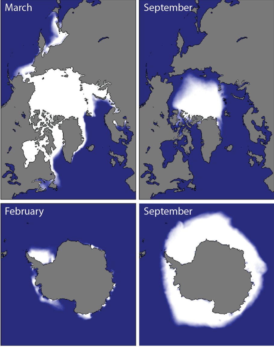
Sea ice is frozen seawater: it forms when the sea freezes and floats at the ocean surface in the polar oceans and surrounding seas. The spatial coverage, known as ‘area’ or ‘extent’, of sea ice varies dramatically between summer and winter; the minimum occurs in late summer and the maximum in late winter.
| Region | Late Summer Min |
Late Winter Max |
|---|---|---|
| Arctic | September | March |
| Antarctic | February | September |
Sea Ice Characteristics
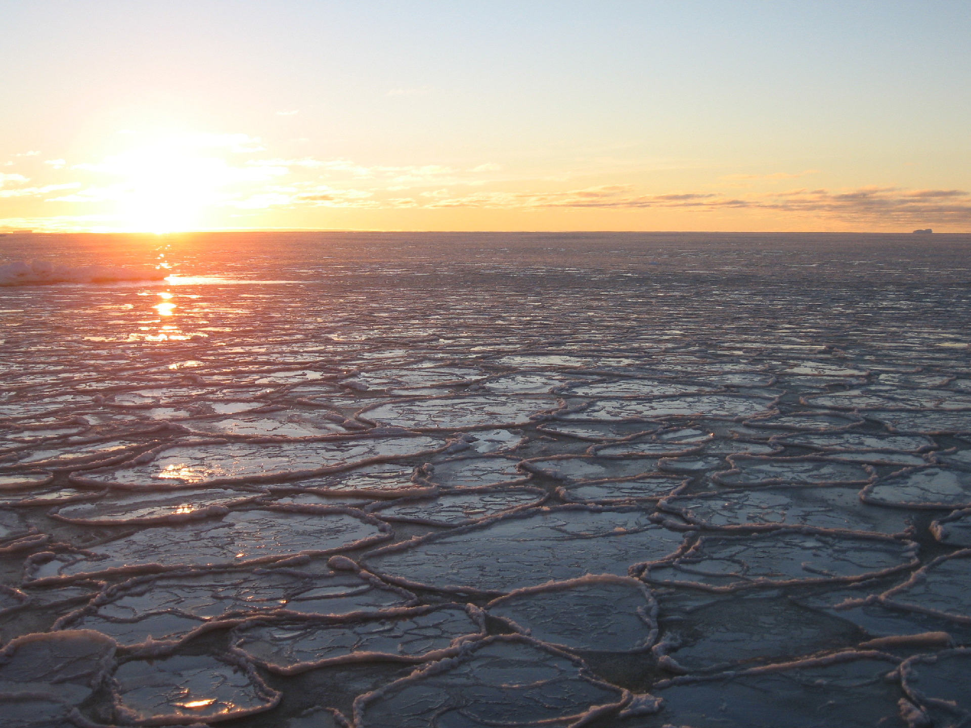
Sunset over consolidated pancake sea ice in the Bellingshausen Sea, 2006/2007 (Credit: Paul Holland, BAS)
Satellite-based estimates of sea ice
extent in different seasons.
Satellites have provided estimates of sea ice extent since 1978. These data have shown a long-term
loss in the Arctic, and a rapid loss in Antarctic sea ice over the last decade.
The maps on the right show sea ice concentration climatologies (1981-2010) in months of
maximum and minimum extent, which is the proportion of the sea surface covered by sea ice. Bright
white indicates 100% coverage with lower concentrations in shades of blue.
Mapping Data Source: National Snow and Ice Data Center (NSIDC), produced by MAGIC
Department at BAS.
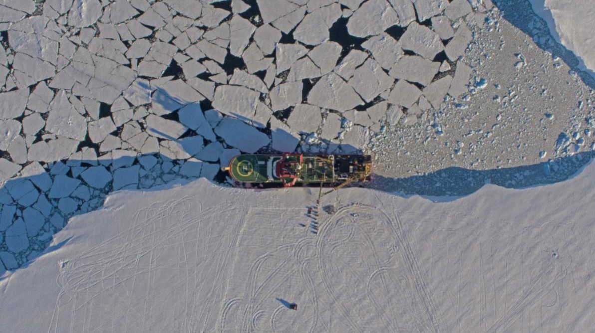
This image shows the contrast between thick ice shelves (ice that formed on land but
has flowed out to sea whilst remaining attached to the ice sheet; lower half of the image) and
broken sea ice, which is thinner ice that formed in the sea (upper half of the image).
RRS Sir David Attenborough moored at Gromit's Creek, Antarctica 2024/25. (credit: Pete Bucktrout, BAS)
Sea ice retreat matters to weather and climate outside the polar regions
Sea ice is an important component of the climate system because it regulates the amount of energy entering
the climate system from the sun and the transfer of heat and momentum between the atmosphere and the ocean.
Sea ice loss is linked to faster warming in the poles than the global average, a phenomenon known as
polar amplification
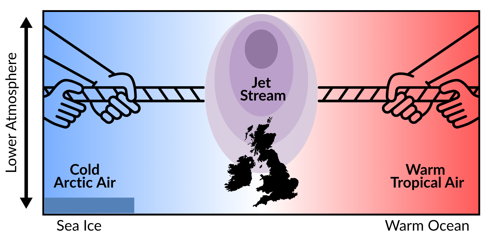
The weather at mid-latitudes, where the UK is positioned, is fundamentally linked, through the location
of the jet stream, to the difference in temperature between the cold Arctic to the north and the warm
sub-tropics to the south. Storms preferentially form in regions of strong temperature gradients due to
their key role in the poleward transfer of excess heat from low latitudes. Therefore, changes in this
temperature gradient influence the present and future trends in weather and climate over the UK.
Prediction Capability and Research
Approaches to sea ice prediction
Accurate prediction of sea ice conditions can provide valuable insight and decision support at various time and space scales. Two broad approaches can be used for prediction of sea ice, as is done for weather forecasting.
- Dynamical models solve physical equations, often derived from the basic laws of physics, on a three-dimensional grid, to iterate forwards atmosphere, ocean and sea ice conditions.
- Data-driven models derive relationships between variables (for example, past sea ice and current sea ice) and use this to make predictions.
While relatively simple statistical models such as linear regression have long been used in
forecasting, data-driven models now include advanced AI models.
In 2021, Andersson et al. (2021) published the first AI-based sea ice forecasting model, IceNet,
which outperformed dynamical predictions at lead-times of two to six months. Since then,
data-driven models have proliferated with various authors exploring different domains,
architectures and input variables.
Research towards monthly-to-seasonal forecasting
IceNet: a machine learning forecasting system
IceNet is a UK-led sea ice AI forecasting system that has previously been demonstrated to have skill exceeding that of dynamical systems for summer Arctic sea ice. The original version predicts sea ice conditions based on recent sea ice cover and atmospheric conditions.
Benchmarking IceNet for both hemispheres
Recently, IceNet’s performance in the southern hemisphere has been assessed for the first
time, alongside a re-assessment of its performance in the Northern Hemisphere. Models have
been trained and evaluated on test periods selected to characterise both ‘extreme’ and
‘normal’ sea ice conditions.
These periods were 2007 (extreme low in Arctic), 2018
(‘normal’ in both hemispheres) and 2023 (extreme low in Antarctic). In these test cases, the
IceNet consistently outperforms a linear trend forecast at short (1-2 month) lead times, with
mixed performance at longer lead times.
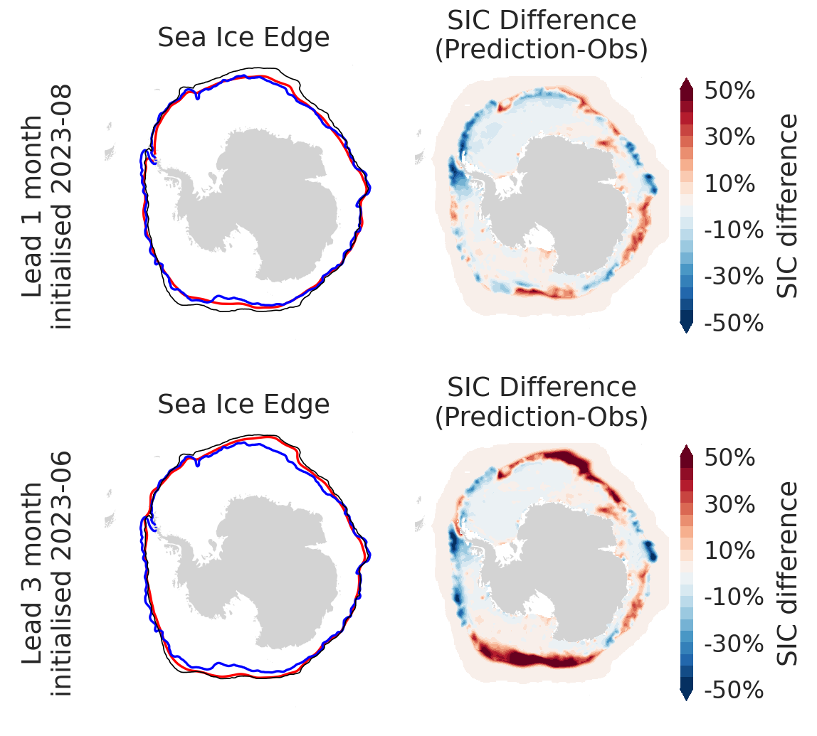
IceNet shows improvement against a linear trend
forecast, although still large errors, for long lead times for the 2023 extreme Antarctic case.
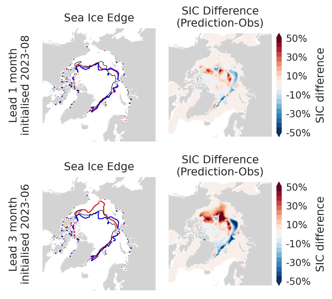
This is demonstrated in the Figure below; for the forecasts produced at 3-month lead time
(bottom), the IceNet forecast largely follows the linear trend prediction, whereas at 1-month
lead time IceNet is providing substantial added information to the linear trend forecast.
Arctic
Antarctica
Figure: Example sea Ice predictions from IceNet without ocean variables for Arctic and Antarctic, forecast September 2023. Models are initialised 1 month (top row) and 3 months (bottom row) ahead. Left hand panels: Red: Sea ice edge (15% sea ice concentration contour) in model; Blue: Observations; Black: Linear trend baseline Right hand panels: sea ice concentration error.
Research extensions: ocean variables
Prior research suggests that there may be a source of predictability at either or both poles
due to heat stored below the ocean surface (Bushuk et al, 2021); the thickness of the ice
(Blockley and Peterson, 2018); and the salinity (salt content) of the surface
waters.
Therefore, ongoing research is exploring the performance of IceNet incorporating ocean
reanalysis (ORAS5) variables into the IceNet training and prediction pipeline, alongside
atmospheric reanalysis (ERA5) variables and sea ice concentration. Specifically, surface
salinity, mixed layer depth, the heat content of the upper 300m and sea ice thickness have
been added. Preliminary results suggest that, with the current IceNet architecture and
configuration, these variables do not improve prediction skill for the test periods
discussed above, or overall performance in training.
Future IceNet extensions: towards operational forecasting
The current IceNet infrastructure uses as input sea ice concentrations from a product that uses
discontinued source data from US satellites. This data was discontinued in 2025 meaning it can
no longer support future operational forecasting capabilities.
Current work is therefore developing the infrastructure to use an ongoing product based on a
different data source. This data is higher-resolution (6.25km rather than 25km spatial
resolution) and ongoing. The shorter data record provides less data for the AI models to learn
from, and it is unclear what impact this will have, if any, on model performance. Existing and
new approaches are being explored to optimise skill and move towards operational forecasting
capability that can be used to inform UK polar resilience.